Understanding India as a Unit of Geographical Study
GS-1, Unit-2, Sub Unit-2, HPAS Mains
India occupies a unique and significant position in the world due to its vast size, diverse physical features, and long history of human civilization. Studying India as a unit of geographical study helps in understanding how its physical environment, climate, natural resources, and human activities are interlinked and collectively shape the country’s identity. Despite immense diversity, India presents a remarkable degree of geographical unity, which forms the basis of its social, cultural, and economic development.
Location and Extent
India is located in the Northern and Eastern Hemispheres and extends roughly from 8°4′ N to 37°6′ N latitudes and 68°7′ E to 97°25′ E longitudes. The Tropic of Cancer passes almost through the middle of the country, dividing it into tropical and subtropical regions. India’s central location in South Asia has historically facilitated cultural exchanges and trade with West Asia, Central Asia, Africa, and Southeast Asia. This strategic location has also influenced its climate, biodiversity, and human settlement patterns.
Natural Boundaries and Physical Unity
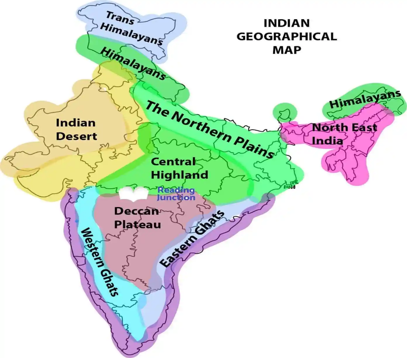
One of the strongest bases for considering India as a single geographical unit is the presence of well-defined natural boundaries. The Himalayan mountain system in the north acts as a formidable physical barrier, protecting the subcontinent from extreme climatic conditions and foreign invasions, while also influencing the monsoon system. In the south, the Indian Ocean, the Arabian Sea, and the Bay of Bengal form natural boundaries that provide India with a distinct peninsular identity.
Within these boundaries, India displays a broad but interconnected physiographic framework. The Himalayan Mountains, the Northern Plains, the Peninsular Plateau, the Indian Desert, the Coastal Plains, and the Islands together form a coherent physical structure. Each region is distinct, yet none exists in isolation. Rivers originating in the Himalayas and the Peninsular Plateau link different regions by supporting agriculture, settlements, and transportation.
Climatic Unity
Climate plays a crucial role in unifying India geographically. The monsoon climate is the most important integrating force across the country. The seasonal reversal of winds brings rainfall to most parts of India, determining cropping patterns, water availability, and rural livelihoods. From the wettest regions of the Western Ghats and northeastern hills to the arid areas of Rajasthan, variations exist, but the underlying monsoon mechanism remains common.
The dependence of Indian agriculture on the monsoon has historically shaped economic activities and cultural practices. Festivals, agricultural cycles, and even settlement patterns are closely linked to the rhythm of the monsoon, reinforcing India’s climatic unity despite regional differences.
Drainage System and Natural Resources
India’s drainage system further strengthens its geographical unity. Major river systems such as the Indus, Ganga, Brahmaputra, Godavari, Krishna, and Cauvery have supported civilizations for thousands of years. These rivers provide fertile alluvial soil, facilitate irrigation, and act as natural transport routes. The interconnected river basins contribute to economic integration by linking hinterlands with urban centers.
India is also rich in natural resources such as minerals, forests, and marine resources, though their distribution is uneven. The Peninsular Plateau is rich in minerals, the Northern Plains are agriculturally fertile, and coastal regions support fishing and trade. This regional complementarity has encouraged interdependence among different parts of the country, reinforcing the idea of India as a unified geographical entity.
Human Adaptation and Cultural Integration
Geography has significantly influenced human adaptation in India. Diverse physical conditions have given rise to varied lifestyles, housing patterns, food habits, and occupations. However, human ingenuity has enabled people to adapt to deserts, mountains, plains, and coastal areas alike. Over time, improved transportation and communication networks have reduced the constraints imposed by physical distance and terrain.
Cultural unity in India has also been shaped by geography. River valleys, mountain passes, and coastal routes facilitated the movement of people, ideas, religions, and languages. Pilgrimage routes, trade networks, and shared ecological challenges fostered interaction among different regions, contributing to a sense of unity amidst diversity.
Conclusion
Understanding India as a unit of geographical study is essential for comprehending its physical structure, climatic patterns, resource distribution, and human development. While India exhibits immense regional diversity, underlying geographical factors such as natural boundaries, monsoon climate, river systems, and economic interdependence bind the country into a coherent whole. This geographical unity has provided a strong foundation for India’s historical continuity and modern nation-building. Studying India through this integrated geographical lens enables a deeper appreciation of how nature and human society interact to shape one of the world’s most complex and enduring civilizations.